Sunday, April 10, 2011

Quilotoa

For one of our last weekends in Ecuador, we decided to go to Quilotoa to see the crater lake there. It took a long time to get there, but it was well worth it once we saw the lake.
This is me at the top of Laguna del Quilotoa.

This is a picture of what we saw the entire way to Quilotoa.

This is in front of our hostel in Quilotoa.

Tuesday, March 29, 2011

Baños, Ecuador

For our four day weekend a bunch of the student teachers and I went to Baños, Ecuador. It’s one of the towns that we’d heard about since before we even arrived in Ecuador because there’s so much to do and see there. We had a long list of things to do before we arrived in Baños, things like: white water rafting, repelling down waterfalls, visiting the active volcano Tungurahua, etc. So, I had been pretty pumped for this trip for a long time because all the outdoorsy things we had planned were right up my alley.
This four day weekend was in celebration of one of Ecuador’s holidays, Carnaval. We knew this when we planned the trip, but we had no idea how crazy the town would be for the holiday. There were people running up and down the streets 24/7 with bottles of silly string type stuff spraying anyone who got close enough. We also had to watch out for the people on rooftops armed with water balloons and the drive-bys of silly string sprayers. So it was pretty crazy in the streets of Baños, which was kind of fun at first but after getting sprayed for 2-3 days straight, I was ready to start throwing rocks. Only kidding... but seriously. ha.
I liked Baños a lot because of the variety of things to do there. Hopefully I will get a chance to go back and see the town again before I leave. And hopefully the volcano will be more active the next time we go because we didn’t get to see any activity from Tungurahua. And it is actually pretty common to see the volcano spitting out spurts of lava at night, but we weren’t lucky this time
Here’s a bunch of pictures we took while seeing the town..

This is overlooking the town of Baños, you can see it’s surrounded by tall peaks on all sides.


This is Amy, Kendal, Evan, me, and Stacy at the twin waterfalls.


This is at a hostel that overlooks all of Baños. It’s a really expensive place so we didn’t stay there, but my homestay family told me it was a must see and they were right.
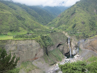

This is one of the incredible views we saw while just riding around Baños in a taxi.


This is me and a Burmese Python.


This is a group shot right after we went repelling down the three waterfalls, which was one of the coolest things I’ve ever done.


This is me repelling down the biggest of the three waterfalls. Probably a 120 foot drop to the bottom.


This is the biggest waterfall we saw in Baños, and we actually got the chance to swim there also.


This is at the waterfall Pailon del Diablo, which is one of biggest attractions in Baños.

Monday, March 28, 2011

Lately in Ecuador

This is part of the 5th grade class that I am student teaching with. Here, we were finishing up a unit on Greek Mythology and each student had to present a Greek character by acting the part, dressing the part, and knowing details about the particular Greek character. They competed against another student who had the same character to see who the REAL Greek character was and who the imposter was.


This is the other half of the class who presented the next day.


This is a random kickball game that we played one afternoon after school.


This is me trying to show the natives how to fish.


This is a school parade that a local elementary school had recently.


John Wayne look-a-like spotted in Ecuador.


Birthday in Ecuador.


Sunday, February 20, 2011

Cotopaxi

This weekend we went to Cotopaxi, the 2nd biggest volcano in Ecuador, it's known for it's amazing views from the top and all around the base of it. As we entered the park, we could see that volcanic rock covered the ground and it started getting much cooler. By the time we made it to the trail head, we were all covered up in much warmer clothes and snow covered the ground. It was really amazing to see the drop in temperature as we climbed, by the time we all reached the Refugio, we we're all craving hot tea so we could warm up. The Refugio was the farthest we could all go without having any serious equipment, and it's honestly as far as any of us wanted to go after reaching the Refugio. Here's a few pictures that we took along the way.
This is Cotopaxi after we had been driving away for almost an hour. It's rarely this clear, so we were lucky to visit on a day like this.

This is where we started our hike to the Refugio, a 1,000ft climb to an elevation of 15,748ft.

This is a group shot at the Laguna at the bottom of Cotopaxi.

This is half way into out 1,000ft climb, we could see everything from up there.

This is a shot down the steep trail we had to hike to get to the Refugio.

This is after we made it to the Refugio, celebration with a fist pump shot.

This is me working my way back down.

Another group shot at the trail head.

This is a random shot that I thought turned out pretty cool.

Wednesday, February 9, 2011

Random

This is the room that I'm living in for my stay in Ecuador.

This is a group shot from the Mindo forest. The girls decided to bring The Brady Bunch to the jungle.

This is me at Mitad del Mundo (middle of the world). They had a line painted there that represented the equator. Supposedly, toilets flush in opposite directions on either side of the line. They had a demonstration, but I'm not sure I'm convinced.

This is another picture that I thought was pretty cool from the Mindo forest.

This is me at a hostel in Mindo on one of the tiny Ecuadorian beds. $15 a night including breakfast, can't really complain about that.

This is Kelley doing "The Robot" before we all went to bed. Ha!

And this is my foot after Goliath the Ecuadorian fell on it during a basketball game. The doctors here even put it in a cast for a few days. In this picture it almost looks like something you'd want to cut off.

Monday, January 31, 2011

Mindo

This is one of the first Mindo peaks we saw when first arriving, and you can see why it's called a raincloud forrest.


This is some of us starting out on one of the Mindo trails to see some waterfalls.


This is all of us heading out to see more of the Mindo Raincloud Forrest.


This is a group shot before we got on the cart to the other side.


This is one of the many bridges we had to cross.


Another shot of the trail we hiked.


This is a trail that climbs up a smaller waterfall to lead to a bigger waterfall.


This is me with one of the smaller water falls we saw.


This is the biggest water in Mindo, and this is what the previous picture led too.


This is a few pictures that I took on our trip to the Mindo Raincloud Forrest. Mindo's rain forrest is the best hiking that I have ever done. I went with eight other student teachers from our Kennesaw group, and I think we were all equally in awe at the amazing scenery around Mindo. A few of us already decided that we are definitely making a second trip back because there is just so much to see there.
The first day we arrived the rain forrest held to its name, and rained the entire day. Which was not as bad as it sounds because once we all were wet, we really did not care anymore. Not to mention that it made the 13 ziplines MUCH faster than usual. I wish I had pictures from the ziplining day, but I was afraid that I'd ruin my camera.
Mindo was an amazing town and hopefully I have some more adventures that will come close to topping it.

Saturday, January 15, 2011

Pichincha 1 - Jake 0

I got up early this morning and went to attempt to climb one of Quito's volcanos, Pichincha. It was easily the hardest climb I have ever tried, three hours later I'm still down. I rode a ski-lift type of thing 4,000ft to the base of the trail, and wow the altitude change was pretty dramatic. The house that I stay in in Quito is at about 9,500ft above sea level, the base of this trail was at about 14,000ft above sea level. I had no idea that was going to be such a big difference, breathing was noticably harder. I saw about five planes fly by while I was up there and all of them were below us, ha. I was pretty sure I'd climb to the top of Pichincha without much of a problem, but 2.5 hours into the hike I was spent. I was sitting there looking at the last ascent knowing that I didn't have it in me, so I turned around and hopefully I can give it another try before I leave. It was an amazing view up there I could see everything, even the clouds were below us once we got as far as we did. I was thinking later that I had climbed to the same altitude that I sky dived from this last summer, pretty amazing.

This is at the beginning of the trail. You can see horses in the background, a lot of people use them to climb Pichincha.

This is one of the really cool views on our climb, the picture doesn't give it justice.

This is one of the neighboring peaks.


This shows Quito below and Cotapaxi in the background, the tallest peak in the world when measured from the center of the Earth.